
Sumatra: Harau Valley > Menhirs > Batusangkar
- Jul 22, 2025
- 3 min read
Updated: Sep 3, 2025
May 8-9 2025 |
Section 3 of my West Sumatra tour. Didn't go as planned, but worked out fine in the end.


After Bukittinggi and Harau, I wasn't sure where to go next. Batusangkar is the logical choice, the historical and cultural center of West Sumatra and a tourist destination. But I had also learned about some POI north of Harau. The first is a menhir site (menhirs = ancient stone rocks/carvings, see"Asterix" for further reference); another is Maura Takus, a 1,000-year-old temple complex thought to have been a Srivijaya-era Buddhist learning center; and the other is Kolok 9, a twisty section of the Bukittinggi to Pekanbaru highway.
Was it possible to do all 3 sites in a loop, without backtracking? According to Google Maps, yes, it was. So I constructed a route through some admittedly isolated territory from the menhirs to Maura Takus, and decided to give it a go, planning to overnight somewhere along the way.
After 1 night in Harau (too short), I hit the road. Once off the main highway towards the menhirs, it's a rural farming area which soon morphs into hills and then mountains. A scenic ride, awesome road, no traffic.


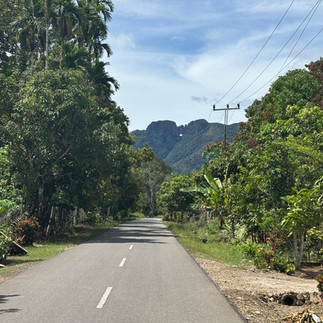

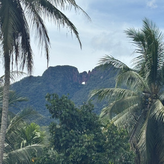
After about 90 minutes, I arrived at the first of 2 menhirs sites, which has a mountain with a hole looming over it. There's no major signage to mark the site from the road, I drove by and need to come back. The site is a small field with a jumble of stone slabs and pillars. It's like a mini Stonehenge, and about the same age. It's worth seeing, though not as "wow" as a similar place like The Plain of Jars in Laos.


From there I rode on through the nearby village, which sits in a river valley surrounded by the tallest non-volcano mountains I had seen thus far in Sumatra. There is another menhirs site in the town, but I couldn't find it. Kept riding for about 2km and then my planned trip suddenly came to an end: the paved road ended at a small bridge, and on the other side, the road turned into an atrocious, steep mud path with deeply gouged tire tracks/water runoffs. Having recently been overconfident and ridden similar "roads" (see my Charlie Hill post in Vietnam), I was not gonna do the same here.


So, I implemented Plan B, turned around and rode 90-minutes back to where I started, Batusangkar my final destination. The ride back was good - back-tracking enables you to see everything you missed that was behind you.
As I was now back on the main highway, I took a route on secondary roads closer to Mount Sago. This was a good choice, an amazing ride with some of the best rural scenery I have seen anywhere in Indo.
After a longer-than-expected day, I finally arrived in Batusngkar, a really nice, clean town, and the historical center of Minankabau culture (and maybe the origins of Malay culture too, I read somewhere). I paid a bit extra for a decent business traveller style hotel. In general, there didn't seem to be much of note in town. But just outside of town, you find some of the most stunning architecture imaginable. The highlight is a massive hall. The level of detail in the buildings is amazing, and speaks volumes of just how deep the culture runs here.


Ride: 140 km / 5 hrs
Stay: Emersia Hotel / $40 ****
Questions or comments?
Drop me a line: terraxplor1@gmail.com